

Emergency Management officials: "Have your plans completed by Tuesday afternoon"

It's time to prepare for another hurricane -- the season waits for no one.
4 P.M. UPDATE -- The Osceola County School District announced: On Monday, October 7, and Tuesday, October 8, school will be in session. All after-school activities, events, and athletics at all schools will operate as normal on Monday but will be cancelled for Tuesday. The district's Extended Day/Learning Program will operate as normal on both Monday and Tuesday. The Osceola County School Board workshop and Board meeting that was to be held on Tuesday, October 8, have been cancelled. The next Osceola County School Board meeting will be held on Tuesday, October 22. On Wednesday, October 9, all SDOC schools and school district operations will be closed. Employees will not report to work unless deemed essential by supervisor. Monitor the district's social media or website at www.osceolaschools.net for any further school district updates.
2 P.M. UPDATE -- Hurricane Hunters Air Force dropsonde data show Milton is now a hurricane with 80 mph winds. "Milton is forecast to rapidly intensify during the next couple of days and become a major hurricane on Monday."
Reports from southwest Florida is that Lee County has already canceled school for Monday-Thursday.
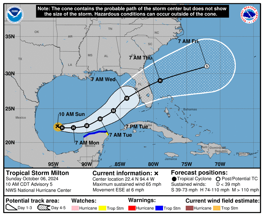
11 A.M. TRACK -- The new National Hurricane Center guidance envelope issued late this morning has a projected track of the center making landfall during the day on Wednesday near Sarasota as a Category 3 storm and crossing the state east-northeastward, existing between Melbourne and Viera. That would make the center cross it through the southern and eastern Osceola County, as a hurricane, and enter the Atlantic overnight into Thursday as a Category 1. (This is north of where Ian entered Florida and near where it existed, for comparisons.) This would still likely bring hurricane conditions to Osceola County, particularly in areas east of Harmony, Holopaw, Kenansville and Yeehaw Junction.
"The new NHC forecast is adjusted south of the previous one, especially early on, and further southward adjustments could be required if the guidance trend continues," forecaster Eric Blake said in the 11 a.m. storm forecast discussion.
Also from the NHC: "Hurricane Watches could be issued as early as late Sunday for portions of Florida." This now comes with advisories for inland counties. We will know more then.
SANDBAGS: With Hurricane Helene fresh on the mind, sandbags will be available at Osceola Heritage Park on Shakerag Road on Sunday (Oct. 6) from 9 a.m. to 5 p.m., and Monday (Oct. 7) from 9 a.m. to 6 p.m. If you got sandbags two weeks ago, you are advised to re-use those filled sandbags that have not come into contact with water as supplies are limited, and sandbags will be available for filling on a first-come, first-served basis. Residents are allowed 25 sandbags per household and will need to bring their own shovel or filling tool, bags will be provided. These sandbags may come in handy as our area could (should?) get 5-8 inches of rain from Wednesday into early Thursday.
Emergency management officials urge those to low-lying and flood-prone areas to plan for a heavy rain and flooding event. They also note that lakes, ponds and other retention areas have the capacity to contain what is expected.
This, also succinctly from Osceola County Emergency Management: "Refill any prescriptions, top off your gas tanks on your vehicles, stock up on non-perishable food items. Please have your plans completed by Tuesday afternoon."
STATE OF EMERGENCY: Gov. Ron DeSantis now placed 51 counties -- up from 35 on Saturday and basically everything in the peninsula part -- under a state of emergency, allowing for things like easing of rules for moving and transporting supplies to where they'll need to be. Tolls may be lifted. Stay tuned.

