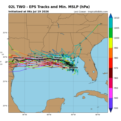
Tropical Depression Two is off the west coast of Florida, expect to track northwest, then west-northwest across the northern Gulf of America. — away from Florida. (Tropical Tidbits)
The "tropical blob" of moisture that forecasters have been talking about for nearly a week formed into a tropical depression Sunday morning, according to the National Hurricane Center.
"There is enough persistent convection near the center and in bands on its northeast and southwest sides to justify this system as a tropical depression," NHC forecaster John Cangialosi said in the storm's initial Discussion.
Tropical Depression Two is off the west coast of Florida, expect to track northwest, then west-northwest across the northern Gulf of America. A Tropical Storm Watch has been issued for Florida from Ochlockonee River to the Alabama border, as it's expected to form into Tropical Storm Bertha.
The storm is expected to produce rainfall amounts of 2 to 4 inches with locally higher totals around 8 inches through Thursday along the eastern and central Gulf Coast from western Florida to southern portions of Alabama, Mississippi, and Louisiana. The NHC forecast its top sustained winds could reach 60 mph before making landfall in southern Louisiana or southeastern Texas later in the week.
What's it mean for our area's weather? A storm to the west often enhances shower activity for us, so expect an unsettled period that could up our rain chances with storms developing earlier and lasting longer than a typical July pattern, at least through Wednesday. Highs should generally stay in the lower to mid 90s, although cloud cover may keep some afternoons from becoming as hot as they otherwise would.