
Storm models show potential hurricane hitting Florida next week


So first, let's get to what we know right now ...
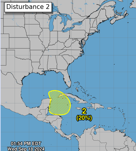
The National Hurricane Center is closely watching a broad area of low pressure in the northwest Caribbean that could develop into the season's next named storm.
"Some slow development of this system is possible through the middle of next week while it moves slowly to the north or northwest over the northwestern Caribbean Sea or the southeastern Gulf of Mexico," the NHC said in its Wednesday afternoon Tropical Weather Outlook.
Beyond that, various computer forecasting models are hinting at a potential impact of a storm, possibly a Category 1, for Florida. The models that say this are nine days out -- anything outside of five days is considered to have "high uncertainty", but these same models have been projecting a version of this for two days now.
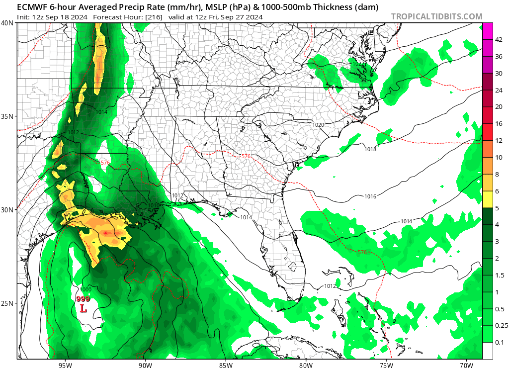
The Wednesday afternoon run of the GFS (American) model shows a hurricane forming in the eastern Gulf, striking the Panhandle around Friday, Sept. 27 -- 210 hours from now -- crawling eastward over the northern part of the state from about Cedar Key to St. Augustine, then stalling out just off the Georgia and South Carolina coast, intensifying to a major hurricane, then heading up the eastern seaboard and potentially impacting the Canadian Maritimes around Oct. 1.
An interesting part of looking at that GFS model across the entire Atlantic basin is that this storm is one of five predicted to form in the Gulf and Atlantic over the next 16 days.
This is close to the solution provided by the CMC (Canadian) model, which has a Category 2 storm impacting Alabama or northwest Florida on the northern Gulf Coast, then heading up into the Tennessee and Ohio River valleys.
Both of these would put Osceola County and the rest of peninsular Florida on the east side, the right side, the "dirty side" of the storm that would bring us feeder bands, blustery winds and the chance of isolated tornadoes.
Better for Florida is the ECMWF (European) model, which keeps whatever develops as a tropical storm and, pushed by a eastern-heading high pressure system, heads northwest toward the Texas coast on Sept. 28.
Again, these are long-range solutions, that will change daily as we got forward. We should watch to see if they continue on a series of future model runs. We at the News-Gazette and AroundOsceola.com will keep you in the know.
And, oh yeah, the first day of autumn comes this Sunday morning. Pumpkin spice everything, everyone?