

Osceola County Commissioners have two — and maybe a third — potential maps and concepts for new districts.
A final map will be adopted by the County Commission at a public hearing on Dec. 6.
New maps are required by the Florida Constitution after each decennial census. According to Article VIII, Section 1(e), “the Board of County Commissioners shall divide the county into commission districts of contiguous territory as nearly equal in population as practicable. Considerations include the demographics of the County, the geography of the neighborhoods, the existing precinct lines, and the best interests of the community.”
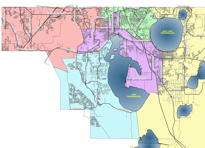
The County’s growth has required making Districts 1 and 5 smaller and expanding Districts 2 and 4. District 3 will see just subtle changes to its boundaries.
The Redistricting Advisory Committee was established by BOCC Resolution 21-232R on Sept. 20 to recommend adjustments to the County Commission districts based on 2020 Census data, which was delayed due to the COVID-19 pandemic.
Three public meetings were held by the redistricting committee, which was chaired by former Osceola County Sheriff Bob Hansell.
The first two conceptualized maps can be found on the county’s website (Osceola.org). They are not yet binding and the County Commission may adjust or consider additional scenarios at its discretion.
Plan A extends District 4 farther west into an area north of John Young Parkway and west of Hoagland Boulevard, and farther east into St. Cloud. It would also extend District 2 to areas along west Osceola Parkway.
Plan B extends District 2 to neighborhoods north of East Lake Tohopekaliga along Boggy Creek Road, and extends District 4 to west Osceola Parkway.
At Monday’s Commission meeting, Count Manager Don Fisher asked for staff to create post online a “Map C” that took in commissioner’s recommendations.