

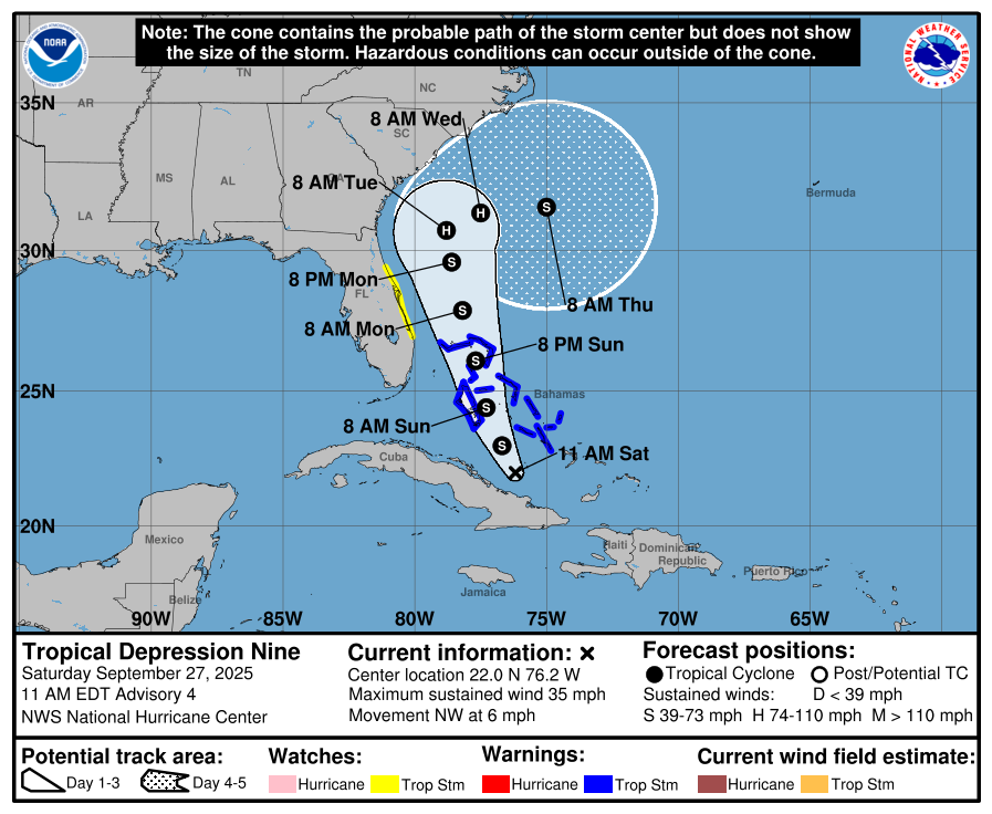
A Tropical Storm Watch is in effect from the Palm Beach/Martin County Line northward to the Flagler/Volusia County Line as the National Hurricane Center announced Tropical Storm Nine formed as of 11 a.m. Saturday.
The NHC has been watching this system for days near Hispanola and now south of the Bahamas, which are under a Tropical Storm Warning as the storm is expected to strengthen into Tropical Storm Imelda.
The current path of projected of movement is northward through the Bahamas, paralleling the Florida Coast about 200 miles away. It will take until Thursday for it to get close to the South Carolina coast, when it is now forecast to turn east into the Atlantic, but that is uncertain as prior forecasts and computer models showed it coming ashore between Hilton Head Island and Myrtle Beach.
"The track forecast beyond 72 hours is still of low confidence ... Much depends on the future track of Hurricane Humberto, the extent to which it erodes the steering ridge over the Atlantic, and the strength and timing of an upper trough expected to dig over the northwestern Atlantic next week," the NHC said in its storm discussion. "Given the risk of tropical-storm-force winds along the east coast of Florida, a Tropical Storm Watch has been issued."
What does this mean for Osceola County? We'll have the usual chance of afternoon storms for late September, but add a breeze out of the north of 15-20 miles an hour. If the storm does not shift further west than currently forecast, this will be "rain with a name". The Saturday 11 p.m. NHC update gave the Orlando area a 12% chance of receiving tropical storm force winds (40+ mph) through Friday.
If anything changes, AroundOsceola.com will update you. Stay tuned, stay aware and stay prepared!

