

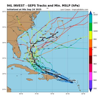
Early ensemble model runs for Invest 94L, which should affect the Bahamas with, at the least, some rain and gusty winds heading into the weekend. (Graphic/Tropicaltidbits.com)
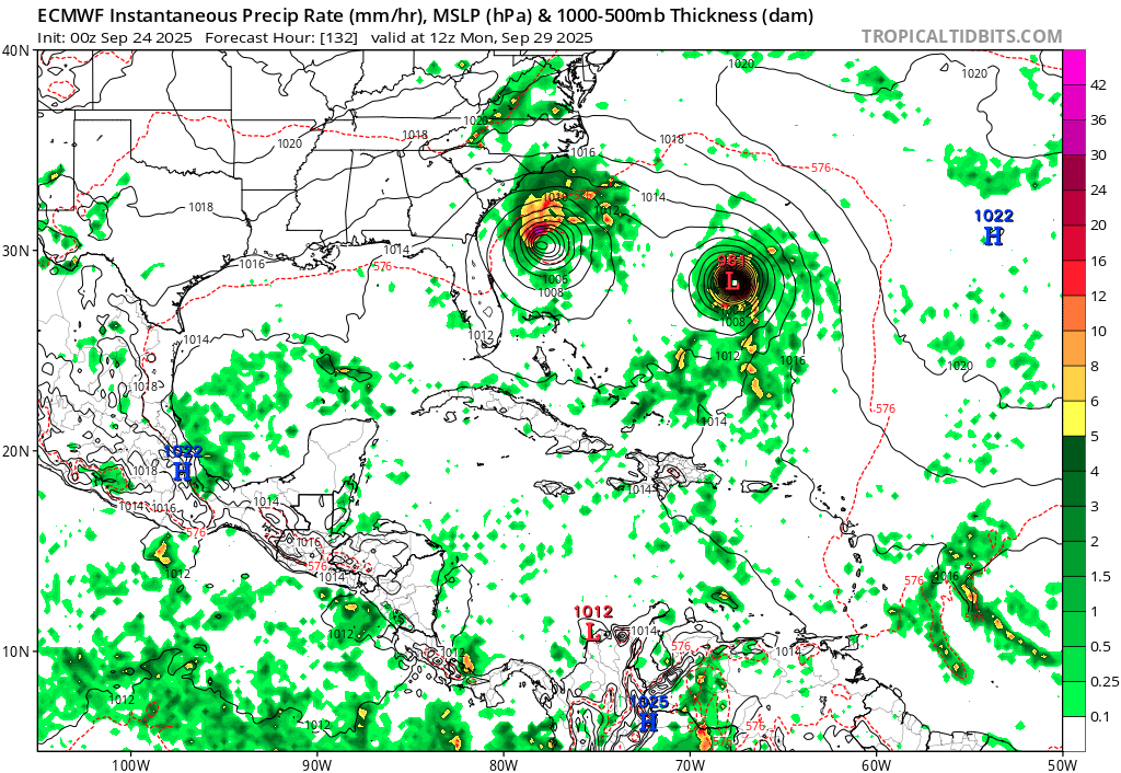
WEDNESDAY 5 P.M. UPDATE: The National Hurricane Center upgraded a disturbance between the Lesser Antilles and Bermuda as Tropical Storm Humberto this afternoon, noting it has top sustained winds of 40 mph.
It is forecast to move slowly over the next three days then head just west of Bermuda, when the NHC forecasts it to be a hurricane, potentially a Category 2. Aside from any swelled surf, it would not impact Florida on that path.
Another system expected to roll past Puerto Rico and Hispaniola through Friday and affect the Bahamas on Saturday could become Tropical Storm Imelda by then. The NHC gives the tropical wave a 30% chance to develop into at least a depression in the next 48 hours and an 80% chance in the next seven days. A Hurricane Hunter mission has been scheduled to sample the budding storm.
"Showers and thunderstorms have increased but remain disorganized, " NHC said about it. "The system is then expected to slow down and turn northwestward when it reaches the southwestern Atlantic late this week. Environmental conditions are forecast to be more conducive for development in a few days, and a tropical depression is likely to form when the disturbance is in the vicinity of the Bahamas."
WEDNESDAY MORNING: After an unusually quiet September in the tropics, Mother Nature has decided to liven things up.
With Hurricane Gabrielle, which rapidly intensified to a major hurricane near Bermuda and now set to cross the Atlantic and affect the Azores islands near Bermuda, a pair of tropical waves may be the next to form just east of Florida.
The National Hurricane Center gives Invests 93L and 94L high chances of developing into a depression, or more, in the western Atlantic. Of most concern to us in Central Florida is 94L, which the NHC gives a 30% chances of forming in the next two days and an 80% chance of organizing in the next week.
The NHC has two hatched "red zones", one that would affect Hispaniola, eastern Cuba and the Bahamas. While most runs of storm models (we'll get to those in a moment) current show that anything that forms out of 94L would likely stay just to the east and pass to the north, it would be "too close for comfort" and at the very least make going to the beach this weekend rather interesting, with an organizing storm out of 93L just to its east.
The NHC predicts heavy rainfall and gusty winds for Puerto Rico and the Virgin Islands later Wednesday, and into Thursday for the Dominican Republic. By the weekend, while models like the GFS ("American") and ECWMF ("European") models develop both, with 94L possibly forming close to or in the Bahamas.
The consensus of the models — at least for now — is that both will eventually curve north, with 93L only possibly affecting Bermuda and 94L possibly a problem for the Carolinas if it's core doesn't curve to the east.
If two storms form — Humberto and Imelda, another 'I' storm, are the next two names on the 2025 storm list — like many of the models suggest, they may interact with each other, what weather experts call the Fujiwhara effect. That could affect those storms' tracks. Dr. Levi Cowan of tropical weather info site Tropical Tidbits alludes to.
"Both waves' future quickly muddies due to their proximity to each other and an upper low that is forecast to sit over the Southeast U.S., this weekend, creating a complex steering environment," he posted on Twitter late Tuesday night. "A general turn northward between a upper low and subtropical ridge is likely for both systems, but it is too early to project the details, which could include some twists and turns in this setup."
We'll keep you posted at AroundOsceola.com, and It's just another reminder, as we come up on the three-year anniversary of destructive hurricanes Ian and Nicole and the one-year anniversary of Helene and Milton, to stay weather aware and check out forecasts this time of year.
Meanwhile, to the west of all that shenanigans, our weather here will get back to being hot and muggy with chances of afternoon storms returning. Highs could reach 94 with the heat index approaching 100 if the rain doesn't cool things down. Essentially, welcome back to September Florida weather.