After a slow June and July to the Atlantic hurricane season -- which isn't uncommon at all -- the tropics, are starting to get active, with three areas the National Hurricane Center are now watching.
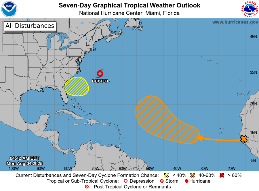
At 11 p.m., the NHC announced an area it's been watching between North Carolina and Bermuda had de-coupled from a cold front to form Tropical Storm Dexter with 45 mph winds. It's expected to stay away from any land masses and only last until Wednesday as an organized system and remain a tropical storm.
The NHC is also eyeing an area off the coast of Georgia and North Florida, which has a low chance of turning into something to watch in the middle or late part of next week for that region -- although weather models aren't picking up on anything during that time frame.
And then, the NHC has noted a tropical wave is forecast to move off the west coast of Africa later today, and begin a possible trek westward across the central tropical Atlantic. A tropical depression could form late this week while it moves generally west-northwestward, and the NHC gives it a 50% chance of developing through seven days.
Long-range models like the GFS are picking up on this, and hint at the possibility of a hurricane being in the western Atlantic to the east of Florida in the time frame of NEXT weekend (Aug. 14-16 or so). You can find those models online (the social media weather zealots will be sharing this soon, that's a near guarantee), but keep in mind they are more than 10 days out, and have little reliability until they get more into the 5-7 day range; the Global Forecast System (GFS) as an example runs that model out ahead that many days out because it can, with small skills of the future weather patterns that steer storms. But it's something we'll keep an eye out for you.
Meanwhile, our weather here is back to "normal" after last week's dry heaves, er, heat — highs in the low 90s, the usual amount of humidity and the regular 40-60% chance of afternoon or early evening thunderstorms.