
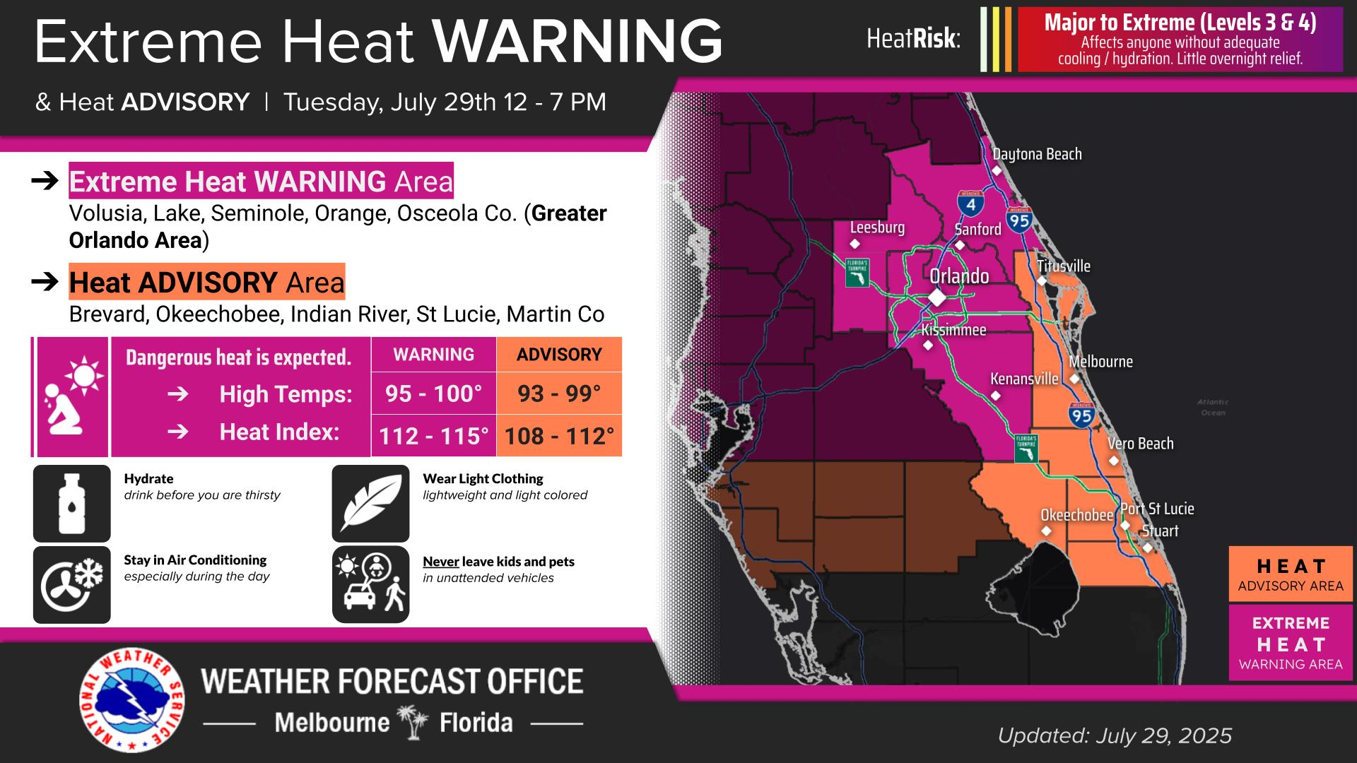
TUESDAY UPDATE: Osceola County is under a rare Extreme Heat Warming for Tuesday.
It's as serious as it sounds. It's above and beyond the Heat Advisory issued every day since Saturday by the National Weather Service in Melbourne.
Osceola, Volusia, Lake, Orange, and Seminole Counties are expected to experience "Dangerously hot" conditions Tuesday, with air temperatures approaching 100 -- the forecast high for today is 97 in Kissimmee, 98 in Kenansville and 99 in Orlando, Sanford and Leesburg; let's just call that 100 -- and heat index values up to 110 to 115 expected, resulting in a Major to Extreme Heat Risk, and the rare advisory in place from 12-7 p.m.
A reporting station at Kissimmee Gateway Airport had a temperature reading of 83 degrees at midnight last night (it was "only" 79 at 7 a.m. this morning). Pray for rain; there's a slight chance of afternoon showers or storms after 4 p.m.
Here's the rest of the NWS advisory for today:
"Drink plenty of fluids, stay in an air-conditioned room, stay out of the sun, and check up on relatives and neighbors. Do not leave young children and pets in unattended vehicles. Car interiors will reach lethal temperatures in a matter of minutes. Take extra precautions when outside. Wear lightweight and loose fitting clothing. Try to limit strenuous activities to early morning or evening. Take action when you see symptoms of heat exhaustion and heat stroke."
An Osceola County Emergency Management official said Tuesday morning that official cooling centers would open should the heat indexes reach 113 or more on one day or 108-112 three consecutive days. Flagler County has recommend its residents visit a Library to escape extreme heat (it's not a bad idea around here, either).
"The worst of it should be around 2 p.m. (Tuesday)," Osceola Emergency Management Director.
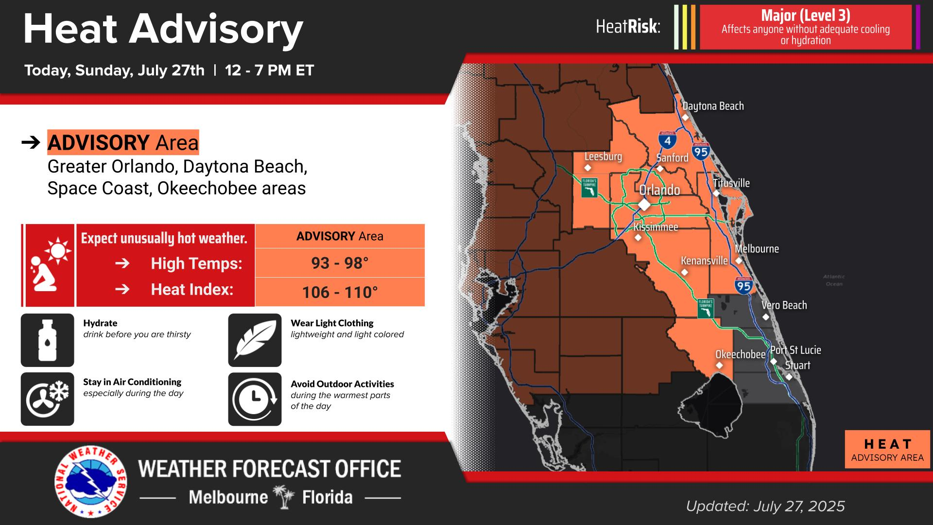
SUNDAY: As temperatures are expected to soar into the mid to upper 90s, and heat indexes should easily eclipse 105, the National Weather Service in Melbourne has issued a Heat Advisory for our area from 12-7 p.m. Sunday, and expect the same on Monday.
Not only will the high temps get as high as 98, the chance of rain is small and the best we can hope for is an isolated passing shower. The NWS calls what we'll experience through early Tuesday "Significant" to "Extreme" heat risk. And if you were thinking of heading to the beach to be refreshed ... "A sea breeze will temper highs along the coast but still reach the low to mid 90s. In addition, increasing low level moisture will produce increasingly humid conditions," NWS Melbourne says.
Thank a strong ridge of high pressure -- a "heat dome" of sorts as what the meteorologists are calling it -- for sending temperatures throughout the Southeast (much of Florida is under the same heat advisories) and well as a good portion of the Midwest. Forecasters say it should start to break up midday Tuesday. While the early-day heat is expected to remain with us into next week, the chance of afternoon thunderstorms returns to the normal level of 60% Tuesday and Wednesday.
Weather officials encourage staying in an air-conditioned room or house between those hours, and if you must be out, wear loose-fitting, light-colored clothing, drink plenty of liquids like water and limit exertion.
Look out for yourself and others the onset symptoms of heat exhaustion -- dizziness, confusion and profuse sweating. If they progress to nausea, seizures and ceasing sweating, and potentially harmful and deadly to the body, and that person must be cooled immediately.
And, before you complain, remember that this time of year in Central Florida rationalizes January and February when most of the country is dealing with snow, brutal cold and wind.