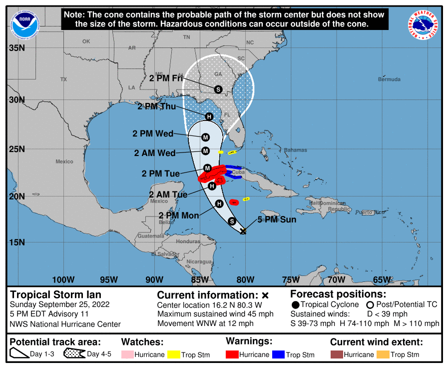
Tropical Storm Ian's maximum sustained winds were still at 45 m.p.h. as of the National Hurricane Center's 5 p.m. Sunday update, but forecasters expect it to intensify into a Category 4 storm north of Cuba.
The current path of projected movement brings the storm into the central or eastern Panhandle during the day on Thursday as a Category 2 storm with 90-100 m.p.h. top winds. It has nudged to the east slightly, the NHC said. A couple of its models still have a projected landfall just north of Tampa; if that happens, Osceola County should expect tropical storm conditions of winds of 40-60 m.p.h. starting Wednesday night, with hurricane conditions possible the first part of Thursday. Heavy rains, with the possibility of 6-10 inches that could cause widespread flooding, are possible in this case, or even if the current projected path pans out, which would bring 30-40 m.p.h. winds.
From NHC forecaster Brad Reinhart: "Users are reminded not to focus on the details of the track forecast at longer time ranges, since uncertainty is still high and future adjustments may be required."
The moral here: BE PREPARED FOR THE WORST. Purchases of storm supplies (water, canned food, batteries and flashlights ... the usual) should be made soon, if not already. Top off gas and propane tanks.
Other NHC notes from Reinhart: "Deep convection will increase during the overnight. Then, significant strengthening is expected with low deep-layer shear and high oceanic heat content along the forecast track. There is still strong support for rapid intensification."
As a Tropical Storm Watch has been issued for the Florida Keys, THIS IS NOW A FLORIDA ISSUE.
The emergency declaration made Friday for the state's 24 southernmost counties, including Osceola, has been expanded to include the entire state. Locally, Osceola County officials canceled a planned Sunday afternoon press conference, but have put some preparations into place. Beginning Monday at 7 a.m., the Osceola Emergency Operations Center will be activated to the elevated Level 2 status. Additionally, the Citizen Information Center hotline (407-742-0000) will open tomorrow morning for citizens that have specific questions or need to speak with an Osceola County representative.
Schools: School District of Osceola County, Superintendent Dr. Debra Pace is continuing to closely monitor the approaching storm along with Osceola County Emergency Management. School will be in session Monday and Tuesday. As the storm’s track and projected impact to Osceola County become more clear, decisions will be made for the remainder of the week. Parents will be notified via the district’s call-out system, Remind texts, on social media, and on district and school websites.
Sandbags: They will be available Monday from 8 a.m. to 6 p.m. at Osceola Heritage Park on Shakerag Road. Supplies will be provided including bags and sand. Residents are allowed 25 sandbags per household and will need to bring their own shovel or filling tool. Supplies are limited, and sandbags will be available for filling on a first-come, first-served basis.
For more local resources, visit readyosceola.org, as well as https://www.osceola.org/agencies-departments/emergency-management/hurricane-center/, which will update information on shelters, flooding and other local updates. Receive emergency phone alerts through Osceola’s free AlertOsceola service by texting the word “alertosceola” to 888777.