Our normal summer pattern of hot and humid into the afternoon and thunderstorms in time for the drive time home is a bit out the window for the next couple days thanks to a trough of low pressure in the Atlantic Monday morning that could form into a weak tropical system in the northern Gulf later this week.
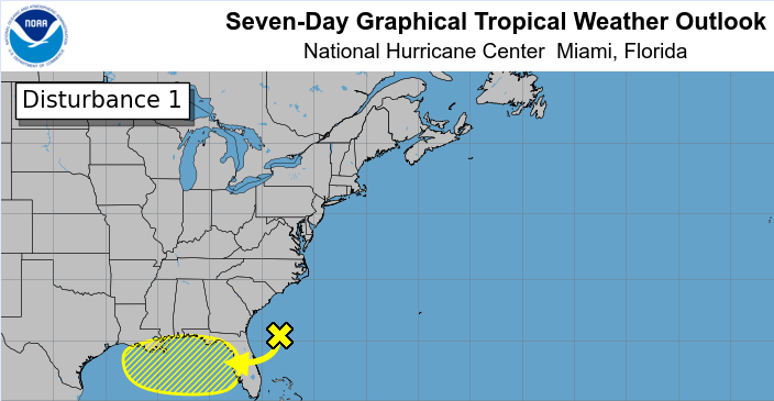
Rain may come Monday and Tuesday morning ... or afternoon ... or even into the evening, as it did Sunday into Monday just after midnight from the north. While it's just an area of unsettled weather now, the National Hurricane Center gives the broad area a 30% chance of developing into a tropical depression or a weak Tropical Storm Dexter around Thursday or Friday.
"Environmental conditions appear favorable enough to support some gradual development of this system while it moves westward to west-northwestward across the northeastern and north-central portions of the Gulf during the middle to latter part of this week," the NHC said Monday morning -- with a warning.
"Regardless of development, heavy rainfall could produce localized flash flooding over portions of Florida and the north-central Gulf coast through the middle to latter portion of this week."
By the time that system makes it into the Gulf, especially if it forms farther to the west, our area should dry out — and heat up — a bit, with highs approaching 94 with lower chances of rain.
The moral of the story is to keep that umbrella handy at all times early this week, even at times you may not expect.