
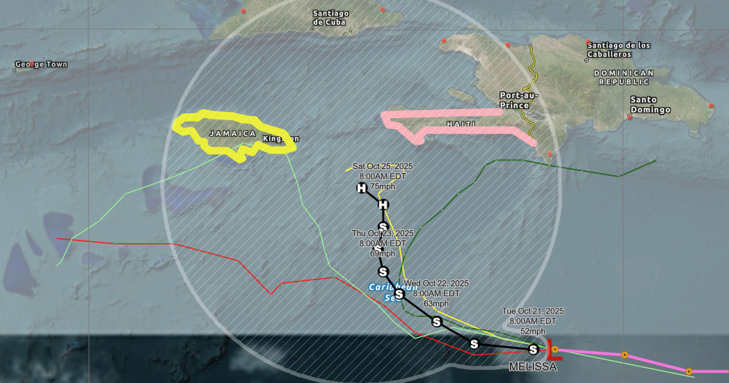
Watches already in place for the islands
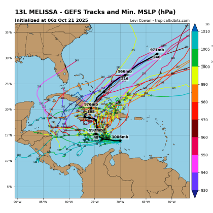
The ensemble matrix of the GFS storm model shows the most likely scenario for Tropical Storm Melissa is to eventually move northeast east of the Bahamas — and away from Florida — in about 10 days as a hurricane. (Graphic/Tropical Tidbits)
The National Hurricane Center officially designated the low pressure system it'd been watching for days as Tropical Storm Melissa at 11 a.m. Tuesday.
It's located about 300 miles south of Hispaniola, which is already under a Hurricane Watch, and east of Jamaica, which is under a Tropical Storm Watch. It's currently moving west, but a gradual turn to the northwest and north is expected during the next few days. On the forecast track, Melissa is expected to approach the southwestern portion of Haiti and Jamaica later this week.
The storm was initialized with 50 mph top sustained winds, and is forecast to become a Category 1 hurricane later in the week. An Air Force Hurricane Hunter aircraft is scheduled to investigate the system this afternoon.
"Their data should provide a better assessment of Melissa's strength and structure," NHC forecasters John Cangialosi and Lisa Bucci said in Melissa's initial storm discussion.
It will also give clarity on the eventual path of projected movement — and the answer to the question "Is it coming to Florida?" Well ...
"Initial guidance diverges significantly with some models like the GFS and HWRF (models) showing a motion to the northeast into a weakness (in a ridge), while the other solutions show a stall or a westward drift on the south side of a building ridge," the forecasters said. "The majority of the (computer ensemble) members show Melissa not moving into the weakness and remaining in the Caribbean Sea throughout the week and into the weekend ... the strengthening trend is expected to be slow and steady, not rapid. However, the future intensity of Melissa is linked to the track and since that is quite uncertain beyond a couple of days, the strength of the storm is also quite uncertain."
Long-range runs of the most reliable models show a higher likelihood of the storm turning to the northeast into the Atlantic Ocean east of the Bahamas. So, to answer (kinda) the Florida question:
The chances of Florida impacts are low and remote — for now. This storm is one to watch and monitor for any changes.