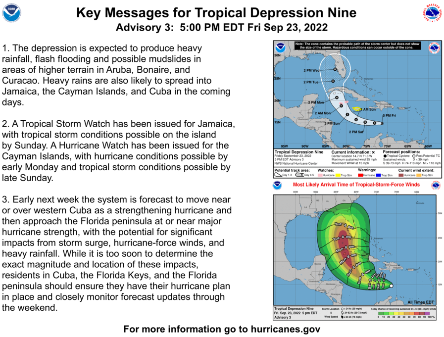
Just before 5 p.m., Governor Ron DeSantis declared a State of Emergency for 24 Florida counties — including Osceola — in the potential path of Tropical Depression 9.
“Today, I signed an Executive Order issuing a State of Emergency due to the threat of Tropical Depression 9,” said Gov.r Ron DeSantis. “This storm has the potential to strengthen into a major hurricane and we encourage all Floridians to make their preparations. We are coordinating with all state and local government partners to track potential impacts of this storm.”
And, where we all thought this would be Tropical Storm, then Hurricane Hermine — think again. A storm just off the African coast attained 40 mph winds at 5 p.m. per the National Hurricane Center, taking that name. So TD9 will eventually become Ian.
And, speaking of the impending storm, it was still a depression in the 5 p.m. update, and, with some computer models tracking a bit more to the west, its projected track was shifted a bit west. The NHC now projects a landfall as a major Category 3 storm very near or just south of Tampa. But, keep in mind, average track errors can be up to 200 miles at day 5, so this is a forecast that will evolve — the NHC even said as much in its 5 p.m. storm discussion.
"Once again, the global models have shifted westward this cycle during this period, and there remains increased track uncertainty late in the forecast period once the cyclone emerges into the southeastern Gulf of Mexico," NHC forecaster Brad Reinhart said.
Some other tidbits from his update:
"The organization of the depression has slightly improved since this morning. The low-level center has been decoupled from the deep convection for much of the day, but in recent satellite imagery it appears the center may be drawing closer to a more recent burst of convective activity ... an Air Force Hurricane Hunter aircraft is on its way to investigate the system this evening ..."
"Recent satellite trends suggest the cyclone may already be nearing a lower shear environment, and once that occurs, the atmospheric and oceanic conditions appear very conducive for strengthening through early next week. As the cyclone moves within a moist and unstable environment over sea-surface temperatures greater than 30 degrees (Celsius), it is forecast to rapidly intensify over the northwestern Caribbean Sea and continue strengthening while it approaches western Cuba on Monday night. The very warm waters of the southeastern Gulf of Mexico should allow for more strengthening once it crosses Cuba, and the NHC forecast once again shows the system approaching the Florida peninsula as a major hurricane by the middle of next week."
Location and intensity updates will now begin coming every three hours (at 8 and 2 p.m. and a.m.) now that a Hurricane Watch has been issued for the Cayman Islands, and a Tropical Storm Watch has been issued for Jamaica.