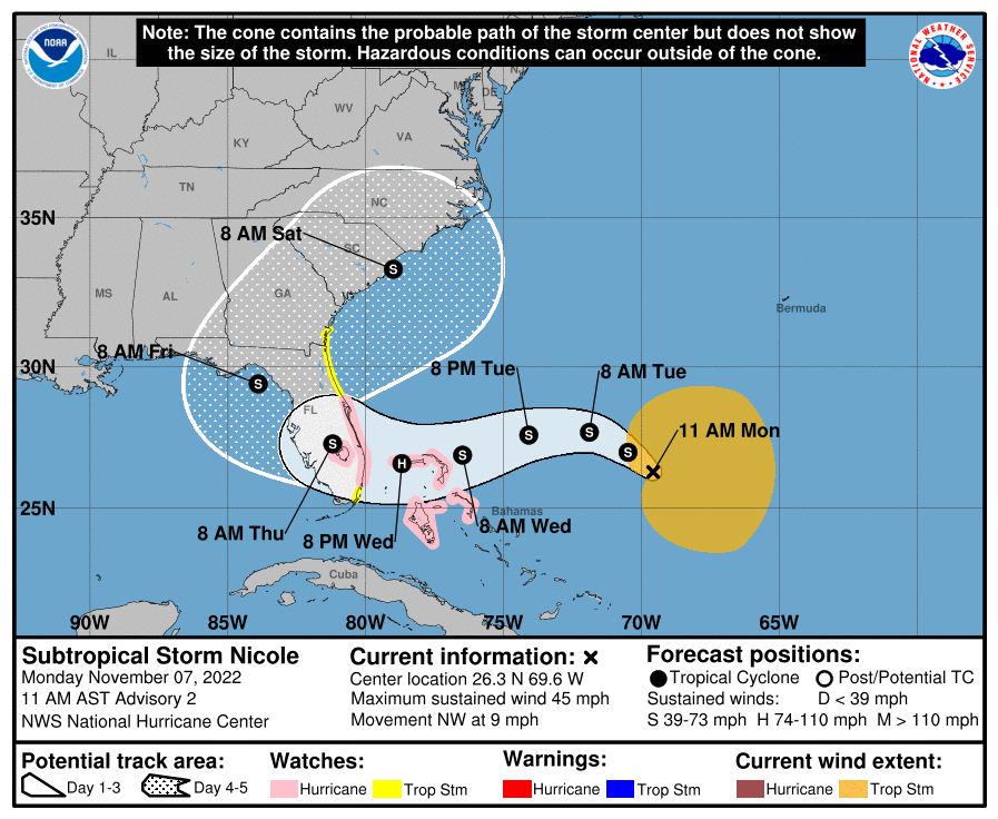
As if Mother Nature needed to remind us that the Atlantic hurricane season runs through the end of November, Subtropical Storm Nicole has formed, and is expected to bring rain to already flood-swollen and wet areas of Osceola County starting late Wednesday, and could last into Friday.
As the News-Gazette advised you could possibly happen back on Friday, the National Hurricane Center named Nicole, with maximum sustained winds of 45 mph, at 5 a.m. Monday. Despite the "subtropical" title -- the circulation is still working its way to the surface -- the NHC said, "Prolonged periods of hazardous weather expected over the Northwestern Bahamas, Florida and the Southeastern coast of the United States this week" as the storm is forecast to move west and slightly southwest and make a landfall in Florida south of us sometime Thursday.
UPDATE: Per the NHC at 10 a.m. A Hurricane Watch has been issued for the east coast of Florida from the Volusia/Brevard County Line to Hallandale Beach. Inland, Tropical Storm watches have been issued for Okeechobee to St. Johns County, including Osceola.
A Storm Surge Watch has been issued for the east coast of Georgia and east coast of Florida from Altamaha Sound southward to Hallandale Beach.
At 10 a.m. Monday the center of the storm was located about 500 miles east of the Bahamas. The current NHC forecast predicts a landfall of a storm tropical storm with 70 mph winds around West Palm Beach, then traversing the state through Friday before a cold front is expected to pick up Nicole and send it quickly up the eastern seaboard Saturday. (If you remember Tropical Storm Fay in 2008, Nicole could be a similar scenario.)
But the rain and wind effects will extend well away from the center, including through much of Florida. Since it will be a multi-day event, our area's biggest impacts will be gusty winds of 30-40 mph with gusts to 50 mph out of the northeast on Wednesday and Thursday and from the south on Friday and Saturday, and rain amounts that could be 2-6 inches -- but that's a forecast that will be updated and refined with any change in the storm track.
Beach erosion from pounding surf is a growing threat for the Florida east coast.
As of 10 a.m. Nicole is forecast to make landfall in the West Palm Beach area as a minimal Category 1 storm. It's all semantics anyway, as effects of the storm will be felt well away from the center — tropical storm force winds are already reaching about 240 miles from the center, mostly to the east of it.
While this would be a storm our community could handle with ease, the recent effects of Hurricane Ian from about five weeks ago make this storm an issue -- and a problem. We'll keep you updated through the week with NHC updates, along with any updates issued by Osceola County officials -- there is a scheduled County Commission meeting at 1:30 p.m.
The NHC will give its next full update at 4 p.m., with position and intensity updates at 1 and 7 p.m. and a.m.