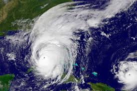
With an above-average hurricane season recently forecasted, the question is how can residents prepare now when dealing with COVID-19?
The Colorado State University Tropical Meteorology Project team is predicting 16 named storms during the Atlantic hurricane season, which runs from June 1 to Nov. 30. Of those, researchers expect eight to become hurricanes and four to reach major hurricane strength (Saffir/Simpson category 3-4-5) with sustained winds of 111 miles per hour or greater.
The report also includes the probability of major hurricanes making landfall:
- 69 percent for the entire U.S. coastline (average for the last century is 52 percent).
- 45 percent for the U.S. East Coast including the Florida peninsula (average for the last century is 31 percent).
- 44 percent for the Gulf Coast from the Florida panhandle westward to Brownsville (average for the last century is 30 percent)
- 58 percent for the Caribbean (average for the last century is 42 percent).
“With the COVID-19, which brings with it an economic impact and recovery to our county residents, will make it hard for resident to have the resources to obtain the supplies for the upcoming hurricane season. The community should still focus on the three steps of: Have a Plan, Build a Kit and Stay Informed,” said Osceola County Emergency Services Director Bill Litton.
So what can residents do to prepare now?
“As the community is shopping for their basic needs each week, they should also take this time while they are at home to review their disaster kits to update their supplies for their kits moving forward,” Litton said.
He added that maybe each week, residents could just add a few food or gallons of water to build up their family supplies before June 1.
“Also residents should review their current insurance policies now before the hurricane season begins, this includes homeowners and renters insurance,” Litton said.
While the forecast calls for an above average season, Litton said there was no reason to hit the panic button.
“The predication are used as a guide for possible outlook and these are not written in stone,” he said. “CSU will update their research at the beginning in the month as we get closer to the start of Hurricane Season, June 1. The main focus that should be communicated that it only take one hurricane to have an impact, do not get caught up in the numbers and predications.”
With health officials stressing social distancing, one issue that comes into play is hurricane shelters. If a storm threat loomed and the coronavirus was still alive and well, county officials would have some thinking to do.
“The county is currently evaluating the plans if we are still being impacted by COVID-19 and need to open an emergency shelter for possible impact,” Litton said.
The above-average Atlantic hurricane season forecast in 2020, is likely due to the absence of El Niño. Tropical and subtropical Atlantic sea surface temperatures are currently warmer than their long-term average values and are consequently also considered a factor favoring an active 2020 Atlantic hurricane season.
The tropical Pacific currently has warm neutral ENSO (El Niño-Southern Oscillation) conditions; that is, the waters are slightly warmer than normal in the eastern and central tropical Pacific. CSU currently anticipates that these waters are likely to cool relative to their long-term averages over the next several months. Consequently, they do not anticipate El Niño for the peak of the Atlantic hurricane season. El Niño tends to increase upper-level westerly winds across the Caribbean into the tropical Atlantic, tearing apart hurricanes as they try to form.
The tropical Atlantic is somewhat warmer than normal right now. Warmer-than-normal sea surface temperatures in the tropical Atlantic provide more fuel for tropical cyclone formation and intensification. They are also associated with a more unstable atmosphere as well as moister air, both of which favor organized thunderstorm activity that is necessary for hurricane development.
So far, the 2020 hurricane season is exhibiting characteristics similar to 1960, 1966, 1980, 1996, and 2008.
“1966, 1980, 1996 and 2008 had above-average Atlantic hurricane activity, while 1960 was a near-average hurricane season,” said Phil Klotzbach, research scientist in the Department of Atmospheric Science and lead author of the report.
The team predicts that 2020 hurricane activity will be about 140 percent of the average season. By comparison, 2019’s hurricane activity was about 120 percent of the average season. The 2019 season was most notable for Hurricane Dorian which devastated the northwestern Bahamas and for Tropical Storm Imelda which caused tremendous flooding in portions of southeast Texas.
The CSU team will issue forecast updates on June 4, July 7 and Aug. 6.
This is the 37th year that the CSU hurricane research team has issued an Atlantic basin seasonal hurricane forecast. Recently, the Tropical Meteorology Project team has expanded to include Michael Bell, associate professor in the CSU Department of Atmospheric Science, and Jhordanne Jones, graduate research assistant in the same department. Bill Gray, who originated the seasonal forecasts, launched the report in 1984 and continued to author them until his death in 2016.
The CSU forecast is intended to provide a best estimate of activity in the Atlantic during the upcoming season – not an exact measure.
As always, the researchers caution coastal residents to take proper precautions.
“It takes only one storm near you to make this an active season,” Bell said.