
Coping with waiting for a traumatic event like what Hurricane Milton may bring can take tips. PHOTO/LEE HEALTH
You're prepared for the storm and trying to cope. Now what?
Ken Jackson
Hurricane Milton is coming to your town. Weathering the storm means preparation. So you're prepared. You've got supplies and a safe space. Your employer may have even closed your place of business and you've got some time at home ... to wait for it to be over. And think about it.
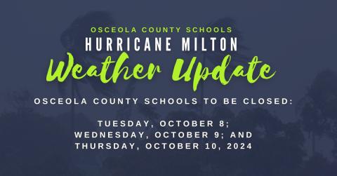
Tuesday, October 8, 2024