
-
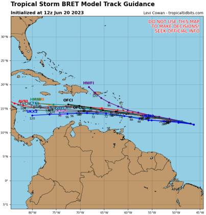 Nearly all computer models keep Bret a tropical storm that will head nearly due west through the Leeward Islands and south of Florida. GRAPHIC/TROPICAL TIDBITS
UPDATE, Tuesday 11 A.M.
The National Hurricane Center no longer predicts Tropical Storm Bret will reach hurricane strength. The NHC even notes it should dissipate by Sunday before reaching Hispanola.
"All of the global models show Bret opening up into a trough in 2 to 4 days as it's passing the Lesser Antilles or after it moves into the eastern Caribbean Sea," NHC forecaster Robbie Berg said in the 11 a.m. storm discussion. "As a result, Bret's forecast intensity in the NHC prediction has been decreased, still allowing for the possibility of some strengthening, but keeping the system below hurricane strength. In addition, the new forecast now shows dissipation by day 5, but if the global models are correct, that could occur even sooner."
Nearly all computer models (with the exception of the outlier HWRF which makes Bret a strong hurricane) keep Bret a tropical storm that will head nearly due west through the Leeward Islands, then take what's left of it toward Honduras and the Yucatan Peninsula — far south of Florida.
Additionally, the NHC is watching Invest 93L to the east of and behind Bret, and give it a good (70%) chance of forming into a depression. If named it would be Cindy, and models run on it thus far show it likely curving north into the open Atlantic.
UPDATE, Monday, 5 P.M. — Tropical Storm Bret
With maximum winds of 40 mph, Tropical Depression 3 was upgraded to Tropical Storm Bret at 5 p.m. Monday. It was located 1,295 miles east of the Lesser Antilles moving west at 20 mph.
"Strengthening is forecast, and Bret could become a hurricane in a couple of days," per the NHC.
Forecasters also note: "Environmental conditions appear conducive for further strengthening over the next few days, with much warmer than normal SSTs along with plentiful mid-level moisture and light shear. The NHC forecast continues to show a gradual increase in wind speed, similar to the model consensus. However, vertical wind shear is forecast to increase by most of the model guidance on day 3 in response to an upper-level trough, along with more dry air nearby. Thus, the NHC forecast shows a slow weakening after that point while Bret is over the eastern Caribbean. There continues to be larger than usual uncertainty."
Bret is forecast to strengthen and move across the Lesser Antilles as a hurricane on Thursday and Friday, bringing a risk of flooding from heavy rainfall, hurricane-force winds, and dangerous storm surge and waves. Everyone in the Lesser Antilles, Puerto Rico, and the Virgin Islands should closely monitor updates to the forecast for Bret and have their hurricane plan in place.
Monday, 11 A.M. — T.D. 3
Here we go, Floridians: hurricane season is in full effect.
An area of low pressure the National Hurricane Center has been tracking for days was officially named Tropical Depression 3 and advisories have started as of 11 a.m. Monday.
The first advisory package forecasts the storm to intensify into Tropical Storm — then Hurricane — Bret, and by Friday (in four days) to be passing through the Leeward Islands as a Category 1 hurricane, and be in the area of Hispanola by Saturday.
But, the NHC calls this first advisory a "a low confidence track forecast." Forecast models that picked up on the storm over the weekend consistently showed an intensifying storm turning north into the open Atlantic.
"A stronger system would tend to move more to the right due to the upper-level flow, while a weaker system would continue more westward into the Caribbean. For now, this forecast lies near the model consensus, and adjustments are likely in future advisories," NHC hurricane specialists Eric Blake and Larry Kelly said in a storm discussion. "Given the larger than usual uncertainty in the track forecast, it is too early to specify the location and magnitude of where these hazards could occur. However, everyone in the Lesser Antilles, Puerto Rico, and the Virgin Islands should closely monitor updates to the forecast for this system and have their hurricane plan in place."
Needless to say, stay updated with the NHC — and of course, the News-Gazette for storm updates.
And if that's not enough, there is a second area of interest right behind it in the eastern Atlantic (Invest 93L0 the NHC is watching, giving it a 40% chance of developing, although it could get sheared apart if it follows TD 3 and that storm intensifies.