
-
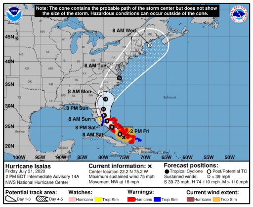 Path of Hurricane Isaias.
The Osceola County Office of Emergency Management is actively monitoring Hurricane Isaias. Potential impacts to Osceola County could include gusty winds and sustained rains, beginning as soon as this weekend.
Florida is no stranger to dealing with disasters and there are a wealth of resources online to help prepare for Atlantic hurricane season, which began June 1 and runs through November.
Osceola County residents should review their disaster preparations and #GetAPlan! The following tips are appropriate for Isaias and other tropical systems:
• Residents should secure loose outdoor equipment and yard debris, and check on pantry and medical supplies – and prepare a disaster supply kit, including food and water.
• Sandbag distribution is not planned at this time
• To prepare a plan for your family and/or business, including how to stay safe during a hurricane or tropical storm, please visit Florida’s Disaster Preparedness site at https://bit.ly/323mpkg
• For the latest weather updates, including storm tracking and forecasts, please visit and follow US National Weather Service Melbourne Florida: https://www.weather.gov/mlb/ and the National Hurricane Center https://www.nhc.noaa.gov/graphics_at4.shtml?start#contents.
• The Osceola County Office of Emergency Management provides resources on its website, https://readyosceola.org
• To receive real-time updates via phone, text or email simply text the word #AlertOsceola to 888777 on your mobile device or online at https://alertosceola.org
“It's never too early to review your hurricane emergency plan -- and if you don't have one you should think about putting one together today -- and making sure you have all the supplies you need,” said Osceola Commission Chairwoman Viviana Janer. “Please keep an eye on the latest weather news from legitimate sources like the National Weather Service and our local news media. Even if this storm passes us by, we should use this as an opportunity to make sure we are ready because it only takes one landfall to make a difference in our lives.”
Hurricane Isaias will move northwest across the Bahamas today and tonight, then move north very close to the Florida east coast over the weekend. The latest forecast brings Hurricane Isaias just offshore of east-central Florida this weekend. Small changes in the track and intensity forecast could result in big differences in local impacts. Outer rain bands and squalls will begin to spread north from South Florida coastal waters by early Saturday, peaking Saturday night/Sunday.
The latest forecast remains consistent in turning Isaias north-northwest and then northward, paralleling the Central Florida Atlantic coast while remaining about 20 to 30 miles offshore at its closest point of approach Saturday night through Sunday afternoon. With the current storm track now only 20 to 50 miles east of the central Florida coast, a small westward deviation could bring strong tropical storm force or even borderline hurricane-force winds to coastal areas.