
-
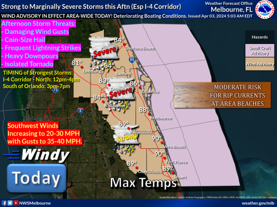 A possibility of strong to severe storms exists for Osceola County from 3-5 p.m. Wednesday. GRAPHIC/NWS MELBOURNE
Wednesday's weather will change into the afternoon and evening drive times ... but it will lead to pleasant, sunny weather through the weekend.
An approaching cold front is bringing the threat for a line of strong to severe storms to move through our area in the 3-5 p.m. timeframe. The line should move through quickly, but what does come has the threat for heavy rain, winds of 40-50 mph and smaller potentials of hail or tornadoes — tornado watches and warnings have already been posted this morning in the Panhandle around Tallahassee.
Ahead of the line of storms, the day will be warm, with highs in the mid-80s, and winds — that are already whipping this morning — of 20-30 mph should be expected.
These storms will be moving in from the west, so western parts of Osceola County (Four Corners, Celebration, Poinciana, Kissimmee) will see the impacts first, followed by Buenaventura Lakes, St. Cloud, Harmony, Holopaw and Kenansville.
By 6 p.m., the heaviest storms should be clearing our area, although rain may linger into the evening. It gives way to a great end of week and weekend, with highs from 75-78 and lows from 55-60 Thursday through Sunday.
We at AroundOsceola.com will update this with changes during the day on Wednesday.