The Central Florida Expressway Authority (CFX) has completed the Project Development and Environment (PD&E) Study for the Southport Connector Expressway, and released documents on the planned thoroughfare.
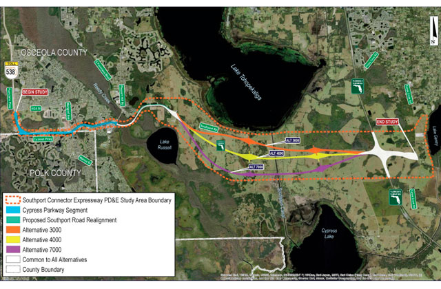
From end to end, State Road 538 would connect Interstate 4 at State Road 429 (the southern end of the Western Beltway) to Florida’s Turnpike and Canoe Creek Road. That path, controversially over the past few years, comes right through the heart of Poinciana, with a planned, raised expressway span down the median of Cypress Parkway to link Poinciana Parkway to the segment west of Pleasant Hill Road. The project would add lanes to Cypress Parkway, making it a six-lane road, and would upgrade several key intersections like Doverplum and Marigold Avenue and the curve where southbound Pleasant Hill becomes Cypress, a long-time choke point for traffic at most times of day.
“The proposed Southport Connector Expressway would provide relief along Cypress Parkway by adding capacity and providing regional connectivity and mobility,” the CFX Project Environmental Impact Report (PEIR) reads. “Improvements also include the proposed inclusion of multi-use paths (eight feet wide) on both sides of the corridor to accommodate pedestrians and cyclists. Together, the Southport Connector Expressway and the proposed improvements to the Cypress Parkway corridor within the study area limits will improve safety and mobility by providing more capacity and travel choices within the region.”
CFX notes that all existing businesses and private property along Cypress Parkway will have road access during and after construction, and that the project will also help important traffic like emergency responders move through the area better.
The study lists “alternatives” that have been studied for the path—but those all are based on the stretch east of the Pleasant Hill-Cypress curve to the Turnpike, passing south of Lake Tohopekaliga past current and proposed housing and Disneyowned ecological preservation land. Three of those proposals are labeled Alternative 3000, 4000 and 7000 from north to south, all meeting back at a point just west of the Turnpike about two miles north of the Canoe Creek Service Plaza, then continuing on 1.3 miles to Canoe Creek Road. Another study will soon begin on State Road 515, a continuation of this road to U.S. 192 and Nova Road between St. Cloud and Harmony.
At least two of the alternatives include a re-routing and widening of Southport Road.
CFX will coordinate with regulatory agencies and nongovernmental organizations, as needed, to address topics of concern such as wildlife impacts to the Lake Russell Cultural Site and Osceola County Environmental Study Center.
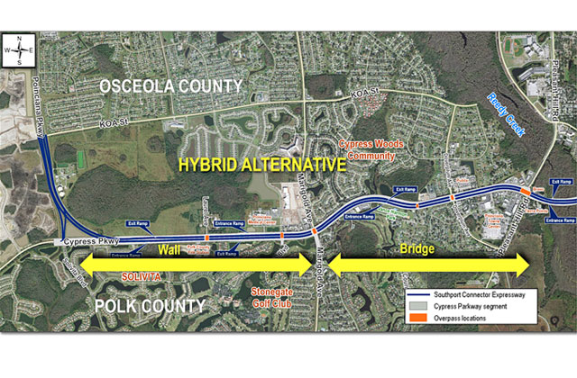
For the western Cypress section, CFX suggested a “wall alternative” with grade separations at intersections. But, while featuring a lower cost, it had the highest number of existing residential and commercial parcel impacts. Dubbed “The Great Wall of Poinciana”, residents argued it would cut off residential areas south of Cypress from the commercial areas north of it.
A “bridge alternative” would have constructed the highway on U-beam structures, but building the entire length of the western leg like that was eliminated due to the high project construction cost and potential recurring cost of maintaining the areas under the entire length of it.
A compromise, through resident input, has been created—a hybrid alternative: building on bridges east of Marigold Avenue, with the wall build from Poinciana Parkway to Marigold. That alternative, according to the PEIR report, is “proposed to be further evaluated.”
And, to see it in print in the study … the road is coming.
“The No-Build Alternative does not meet the future traffic needs through the year 2045 nor the purpose and need for the project to accommodate future transportation demand or improve system connectivity,” the study reads. “The No-Build Alternative remained under consideration throughout the PD&E Study for public input and to provide a comparison to the Preferred Alternative.”
And, public input will continue on the project: “CFX commits to conducting an additional public meeting during the design phase of the project” The study, which includes detailed noise impacts, wetlands and water quality studies for the portion east of Pleasant Hill, can be found at: https://www.movepoinciana.com/wp-content/uploads/599-233Project-Environmental-Impact-Report-FINAL.pdf.