


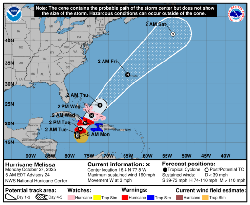
The five-day forecast for Melissa. (Graphic/NHC)
MONDAY 5 A.M. UPDATE — Hurricane Melissa officially became a catastrophic Category 5 storm Monday morning, with a tight core of 160 mph winds but a wide swath of hurricane force winds and torrential rains that could bring 30 inches of rainfall to portions of Jamaica Tuesday through Wednesday and also a disaster to the easternmost provinces of Cuba.
For perspective, the storm went from a 70 mph tropical storm Saturday morning to a Category 4 hurricane in 24 hours (It doubled in strength; the National Hurricane Center defines "rapid intensification" as a 35 mph increase in top winds in 24 hours. Melissa doubled that. Wrap your head around that.),
Melissa continues to creep westward at 5 mph, but it is forecast to make a sharp turn north and northeastward, and the center is expected to rake across the island of Jamaica Tuesday and on to Cuba Wednesday into Thursday before a trough is expected to accelerate the storm through the Southeastern Bahamas and Turks and Caicos in the direction of Bermuda by week's end.
"There's really no practical difference in Melissa making landfall in Jamaica at category 4 or 5 intensity, since both categories can produce catastrophic wind damage," NHC forecasters Robbie Berg and Andre Hagen said. "In addition, winds in the mountains of Jamaica are likely to be higher than the winds at sea level, and are likely to add to the seriousness of the situation."
SATURDAY 5 P.M. UPDATE — The National Hurricane Center is now predicting Hurricane Melissa will reach Category 5 status before or when the center of circulation reaches the Jamaican coast sometime Monday.
Now-Hurricane Melissa, with its agonizingly slow speed and a potential to rapidly strengthen into a monstrous Category 4 or 5 hurricane, has the potential to be a humanitarian disaster in the central Caribbean.
The National Hurricane Center upgraded the storm to a Category 1 hurricane with 75 mph top sustained winds at 2 p.m. Saturday, but it is forecast to reach Category 4 with upwards of 150 mph top winds when the eye reaches the southern Jamaican coast Tuesday morning.
The NHC calls it “likely” that a period of rapid intensification, common in robust storms of late, will occur as the storm moves slowly over very warm ocean waters, “the highest oceanic heat content in the entire Atlantic basin.”
While a number of computer ensemble forecast members say Melissa will grow to a Category 5 storm with 160+ top sustained winds, NHC forecaster Phillipe Papin said it is a possibility but is not forecasting that due to higher than normal track uncertainty.
Still, Weather Channel Tropical Weather Expert and former NHC director said Melissa could have “the combined impact of (hurricanes) Harvey, Dorian and Helene” in Jamaica and Cuba on the Weather Unfiltered show Friday night.
Hurricane watches and warnings are in place for Jamaica and southern Haiti, where Melissa is expected to bring total rainfall of 15 to 25 inches into Wednesday, and could bring more afterwards if the motion remains slow.
“Nearly all of the reliable track guidance shows Melissa making landfall in Jamaica sometime in the 60-72 hour time frame,” the NHC said in a public advisory on the storm Saturday. “Catastrophic flash flooding and landslides are expected across southwestern Haiti and portions of Jamaica, with the possibility of catastrophic flood impacts also extending across the remainder of southern Haiti into southern Dominican Republic.”
Storm surge of 7 to 11 feet is also expected in those areas, and there is a potential for significant storm surge along the southeast coast of Cuba early next week.
Since being named a storm at 11 a.m. Tuesday, Melissa has only moved about 280 miles in four days and three hours thanks to week steering currents. The motion is forecast to continue to be slow through Tuesday into Wednesday, when forecasters say the storm will finally feel the effects of a trough digging into the eastern United States that will quickly shuffle Melissa off to the northeast into the Atlantic.
On this track, there is no expected direct effects in Florida, although surf conditions on the East Coast and in the Bahamas could be rougher than normal into the mid-part of next week.

