
-
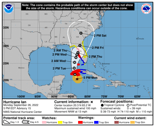 The 5 p.m. cone of projected movement for Hurricane Ian, now a Category 2 storm with 100 mph top winds. GRAPHIC/NHC
Hurricane Ian is now a Category 2 storm, with maximum winds of 100 mph, per the National Hurricane Center’s 5 p.m. advisory package. The NHC advises it will reach a peak intensity of 140 mph (Category 4) in the southeastern Gulf of Mexico before losing some punch due to wind shear before making landfall near or north of Tampa Bay.
A Flood Watch has been added to the Tropical Storm Watch that Osceola and adjoining counties are under. A Tropical Storm Watch is now also in effect for the east coast of Florida north of Jupiter Inlet.
“A turn to the north-northeast with a decrease in forward speed is forecast on Wednesday and Thursday as the center of Ian moves near the west coast of Florida. The slower forward motion is likely to prolong the storm surge, wind, and rainfall impacts, especially along the west coast of Florida,” NHC forecaster Brad Reinhart said in the storm discussion. “The latest track guidance has come into better agreement on this scenario, although it is noted that small deviations to the shore-parallel track could have large implications on the impacts at particular locations along the west coast of Florida. The NHC track forecast has again been adjusted slightly eastward at 48-72 h, which follows the latest trends in the global model guidance.”
The expectations of storm effects locally remains the same: potential for 40-60 mph winds and 4-8 inches of rain.
Schools: Osceola County schools will be closed from Tuesday through Thursday. Check back with us for further updates.
Osceola County and the city of St. Cloud have declared local states of emergency in order to quickly respond to Hurricane Ian. The city of Kissimmee is expected officially ratify its order at tomorrow night’s Commission meeting. These acts make it easier to receive FEMA reimbursement for storm cleanup.
Fire Chief Jason Miller updated the St. Cloud City Council during a special Monday morning. He noted that the winds will be the heaviest here from early Wednesday evening through early Thursday afternoon. Some isolated locations could receive 16 inches of rain through Friday, as the storm is expected to slowly traverse the state’s west coast.
Police Chief Doug Gierke said he will be riding patrol during the storm with officers as long as conditions allow it.
Sand bags will be available Tuesday from noon-7 p.m. at the St. Cloud Civic Center on 17th Street. Sandbags will continue to be available tomorrow, September 27, at Osceola Heritage Park, in partnership between Osceola County and the cities of Kissimmee and St. Cloud.
Shelter Information: The Osceola County Special Needs Shelter will open on Tuesday, September 27, at 2 p.m. at the Council on Aging, located at 700 Generation Point, Kissimmee, FL 34744. Please remember that individuals staying at the special needs shelter should bring medicine and other vital supplies including oxygen or other electric medical devices. For more information, please call the Osceola County Special Needs hotline at 407-742-9001.
Osceola County’s three general population shelters will open on Tuesday, September 27, at 2 p.m. Those general population shelters are:
- Celebration High School – 1809 Celebration Boulevard, Celebration, FL 34747
- Kissimmee Middle School (Pet-Friendly) – 210 Dyer Boulevard, Kissimmee, FL 34741
- Harmony High School - 3601 Arthur J Gallagher Boulevard, St Cloud, FL 34771
Trash collection: Today and Tuesday, brown bins and special pickups will be on normal schedule. Curbside, special pickups and all Transfer Station operations will be closed Wednesday, and will resume operations Thursday or as soon as practical thereafter. Wednesday's green yard waste bin pickup will be postponed until next week. At this time, the City expects Thursday and Friday recycle blue bins to be picked up on the normal schedule, but that may change depending on the storm's impact. City clam truck drivers will be picking up as they are able. It is the responsibility of residents to properly secure all debris on their property to keep it from becoming an airborne hazard during the storm. The City will schedule special pickups after the storm, once all necessary cleanup is completed. The City anticipates resuming scheduled special pickups Oct. 3.
Streets Department has been clearing drains.
More St. Cloud: The City will open a phone bank Tuesday at 8 a.m. for citizens to call with questions about Hurricane Ian. Citizens should call 407-957-7161 for information about sandbags, storm preparation, resources, shelters, and more.
Additionally, we urge our citizens to text “alertosceola” to 888777 to receive important storm updates, and follow the City’s Facebook and Twitter pages for updates throughout the week.
A number of City meetings, events and activities planned for this week are being canceled or postponed as Florida prepares for Hurricane Ian.
Cancellations:
· Little League games Tuesday, Wednesday, and Thursday, Sept. 27-29
· Soccer fields will be closed Tuesday, Wednesday and Thursday, Sept. 27-29
· Downtown Monthly Market on Wednesday, Sept. 28
· Citizen’s Academy on Wednesday, Sept. 28
· All aquatics programs Wednesday and Thursday
· Lunch & Learn Wednesday, Sept. 28
· Walking Club Wednesday, Sept. 28
· Crafty Ladies Wednesday, Sept. 28
· Council on Aging at Community Center, Thursday, Sept. 29
· All activities at Hopkins Park Wednesday and Thursday, Sept. 28-29