
Effects from soon-to-be Debby should start Sunday morning
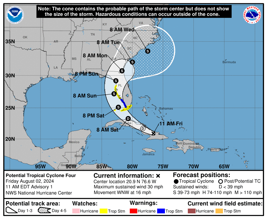
In a sign that the tropical wave over Cuba this Friday is getting its act together, the National Hurricane Center has started issuing advisories on Potential Tropical Cyclone 4 — what it expects to become Tropical Storm Debby — and has issued tropical storm watches and warnings for the west coast of Florida.
Since National Weather Service and county officials expect the impacts to be more rain than wind-driven, operations to get sand bags will begin Friday at 3 p.m. at Osceola Heritage Park. It will be 3-7 p.m. Friday (don't arrive too early, the Jehovah's Witnesses are having a convention in the Silver Spurs Arena this morning), and from 9 a.m. to 6 p.m. Saturday.
Residents are allowed 25 sandbags per household and will need to bring their own shovel or filling tool. Supplies are limited, and sandbags will be available for filling on a first-come, first-served basis.
"Residents in low-lying and flood-prone areas are urged to review their plans for heavy rainfall events," Osceola County said in a release late Friday morning. "Based on observations, the County’s lakes and ponds have ample capacity to handle the expected rain."
So, how much rain? The NHC said in its initial storm advisory, "Potential Tropical Cyclone Four is expected to produce rainfall totals of 4 to 8 inches, with maximum rainfall totals up to 12 inches."
If you are looking for perspective ... Hurricane Ian moved slower (8 mph) than this storm (16 mph) is expected to move, and the rain will likely be in a constant downpour that starts midday Sunday and lasts into Monday, where Ian brought a 24-hour deluge. If your area flooded significantly in Ian, it is worth being concerned about this storm.
NHC storm forecaster Jack Beven noted in that first advisory that the potential for development once the system moves over water on Saturday is anticipated; Debby is now forecast to pack 65 mph winds when it's center reaches the Tampa Bay area Sunday evening. Only a couple of the dozen or so intensity models forecaster track bring the storm to hurricane strength.
"Slow development is possible while the system is over Cuba, and the system is likely to become a tropical depression soon after it moves offshore," Beven said. "The environment over the Gulf of Mexico is quite favorable for strengthening with light shear and very warm sea-surface temperatures, so subsequent steady strengthening is expected. The two biggest uncertainties in the intensity forecast are how long the system will remain offshore of Florida and how long it will take to consolidate."
A Tropical Storm Warning is in effect from East Cape Sable to Bonita Beach on the southwest coast, and the Florida Keys and the from Bonita Beach to Aripeka (north of Tampa). "Additional warnings and watches may be required for a portion of this area tonight and Saturday," the NHC said. Had this storm occurred after Aug. 15, the NHC might have issued those storm watches and warnings for inland areas; it's a new program it will start this year.
As always, to receive instant weather reports and emergency alerts during storms, use Osceola’s free AlertOsceola service, by texting the word “alertosceola” to 888777.
The state has been working since earlier in the week to prepare. Thursday, Florida, Gov. Ron DeSantis issued an executive order placing 54 Florida's 67 counties, including Osceola, under a a state of emergency. It's pretty much the counties that I-4 travels through, and everything north and west of that.
The declaration eases the ability to move state and federal assets into areas that may need assistance before, during and after the storm, and hasten response. The order directs Emergency Management Director Kevin Guthrie to coordinate the state’s approach to the storm and any recovery operations.