
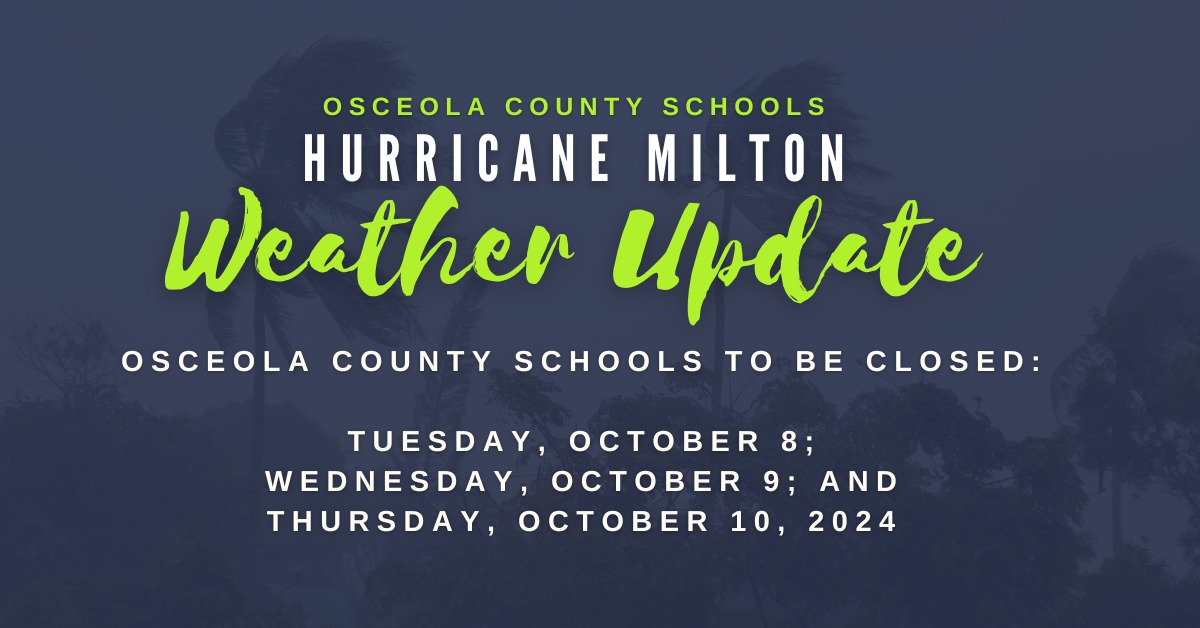
MONDAY 5 P.M. — From the Osceola County School District: "After consulting with state and local officials and in response to the evacuation cadence of the western side of the State, we are closing schools and district offices Tuesday, October 8."
The Hurricane Watch has been changed to a Hurricane Warning, meaning those conditions we talked about earlier today are now EXPECTED, likely early Thursday morning. (Everything else reads as it does below from earlier in the day.
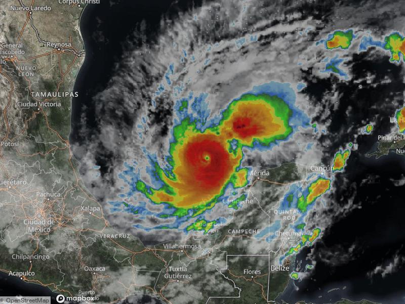
The 5 p.m. NHC advisory on the storm showed a still-robust Category 5 with 180 mph maximum winds, over just a small area — hurricane force winds extend 30 miles from the center, and tropical storm force winds extend out 80 miles. Hurricane Helene's winds were three times that wide, explaining why we felt 40 mph winds with a storm that was 100 miles out into the Gulf.
MONDAY, 12 P.M. — A Hurricane Watch has been issued for parts of inland Central Florida, including Osceola, Polk, Orange, Seminole and Lake counties. That means that hurricane conditions are possible within the next 48-72 hours. (This may be upgraded to a Warning, which says those conditions are EXPECTED within 24-36 hours, tonight or tomorrow.)
According to the National Weather Service, Osceola County should, "Plan for life-threatening wind of equivalent Category 1 or 2 hurricane force (74-110 mph)."
What would be the impact of that? From the NWS: "Considerable roof damage to sturdy buildings, with some having window, door, and garage door failures leading to structural damage ... Mobile homes severely damaged, with some destroyed. Damage accentuated by airborne projectiles. Many large trees snapped or uprooted along with fences and roadway signs blown over. Some roads impassable from large debris."
The most likely scenario on the current forecast path (which will likely still change a bit prior to landfall) would put our area, depending on where you are (Celebration vs Poinciana vs Kissimmee vs St. Cloud vs Holopaw vs Kenansville, if you get the drift) would be sustained winds of 65-85 mph with gusts to 100 for a period of a few hours — likely overnight Wednesday into early Thursday morning (unfortunately, during darkness).
With that, expect widespread power loss, at least temporarily. While KUA will do its best, keep in mind when wind speeds reach 45 mph or more, crews can no longer safely restore power.
Mutual aid crews from Minnesota are in route to Kissimmee to provide assistance with potential restoration efforts. "KUA crews are prepared to work long hours after the storm passes, restoring service to customers as quickly and as safely as possible."
To report outages: Customers who experience a power outage can report it quickly by texting the word “out,” to 877-582-7700. This is the fastest way to notify KUA about an outage.
The Osceola County School District announced schools will be closed Wednesday AND Thursday. They will be open on Tuesday, but all after-school activities (except for elementary school extended day care) are canceled. Some schools will operate as shelters starting at 8 a.m. Wednesday. Superintendent Mark Shanoff said any info past Thursday will come from any damage reports, information will be shared through its phone messaging and social media channels and website www.osceolaschools.net.
Gov. Ron DeSantis said tolls will be suspended at 10:30 a.m. Monday.
SunRail has said it will suspend operations Tuesday through Thursday.
It's easier to just say this: everything of official capacity is closed on Wednesday and Thursday. Osceola County Emergency Manager Bill Litton has asked residents to stay off of roads Wednesday and the first part of Thursday. Sheriff Marcos Lopez reiterated that.
MILTON IS BREAKING ALL THE RULES — AND THE RECORDS: Storms aren't supposed to cross the Gulf from west to east. And they aren't supposed to intensify as rapidly as this.
Milton, a tropical depression at 11 a.m. Saturday and a tropical storm two hours later, was a Category 5 hurricane with 175 mph top winds at 2 p.m. Monday. The winds have increased 95 mph in 24 hours and 135 mph in 48 hours. The central pressure was 911 millibars, a drop of 64 mb in 12 hours. The only storms that have intensified faster were Hurricane Wilma in 2005 and Hurricane Felix in 2017.
Keep in mind that the storm IS NOT FORECAST TO REACH THE FLORIDA COAST AT THIS INTENSITY. Wind shear, dryer air and cooler waters (already traversed by Helene two weeks ago) are expected to weaken Milton to a Category 3 with 125 mph winds (still nothing to mess with) by expected landfall Wednesday night.
Again, expect Category 1-2 conditions in Osceola County overnight — unless things change, and if they do, we'll tell you as soon as they do.