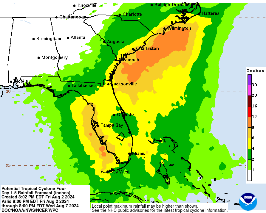
Impacts to Osceola: 3-6 inches of rain, possible flooding, a bit of wind
A bit of change at 11 p.m.to the tropical system the National Hurricane Center has been watching now for nearly a week: it's become Tropical Depression Four, and the path of projected movement has edged to the west.
It is now forecast to make landfall early Monday morning in the Panhandle or Big Bend area -- the same place severely impacted by Hurricane Idalia just under a year ago -- as a strong Tropical Storm Debby, or possibly a Category 1 hurricane.
But, that's just the certain, and what should become Tropical Storm Debby sometime Saturday is expected to be a right-loaded storm, meaning our area will be on the "dirty" side and should see about a day of tropical rains and the possibly of short-lived tornadoes.
Sand bags will be available on Saturday at Osceola Heritage Park from from 9 a.m. to 6 p.m.
At 11 p.m. Friday, the NHC noted the center of the storm was over water and not the land of Cuba as it had been all Friday. This gives the storm more time to strengthen. The current projection is Debby is to make landfall as a 70 mph tropical storm, just before the precipice of a hurricane.
"It is important to note that because of the forecast track being parallel to the west coast of Florida, the location and timing of a potential landfall cannot be pinned down at this time," NHC Tropical Forecaster Robbie Berg said in the 11 p.m. storm discussion.
Inland counties Polk, Lake and Sumter, all close to Osceola, are under Tropical Storm Watches as of 8 p.m. Sunday. Early projects are that Osceola County could see 3-7 inches of rain between late Saturday night and Monday morning, with the higher tallies on the west side of county (ChampionsGate, Celebration, Reunion). If the storm does take the current path, winds should be in the 25-35 mph range on Sunday. The NHC lists Orlando as having an 11% chance of receiving tropical storm force (40+ mph) winds through Tuesday.